Wedding Song - God Knew That I Needed You

Sunday, August 7, 2022

MOD BABY JACKET & EARFLAP HAT; NB-3 MO. GIRL; Knit – Bulky Weight Yarn

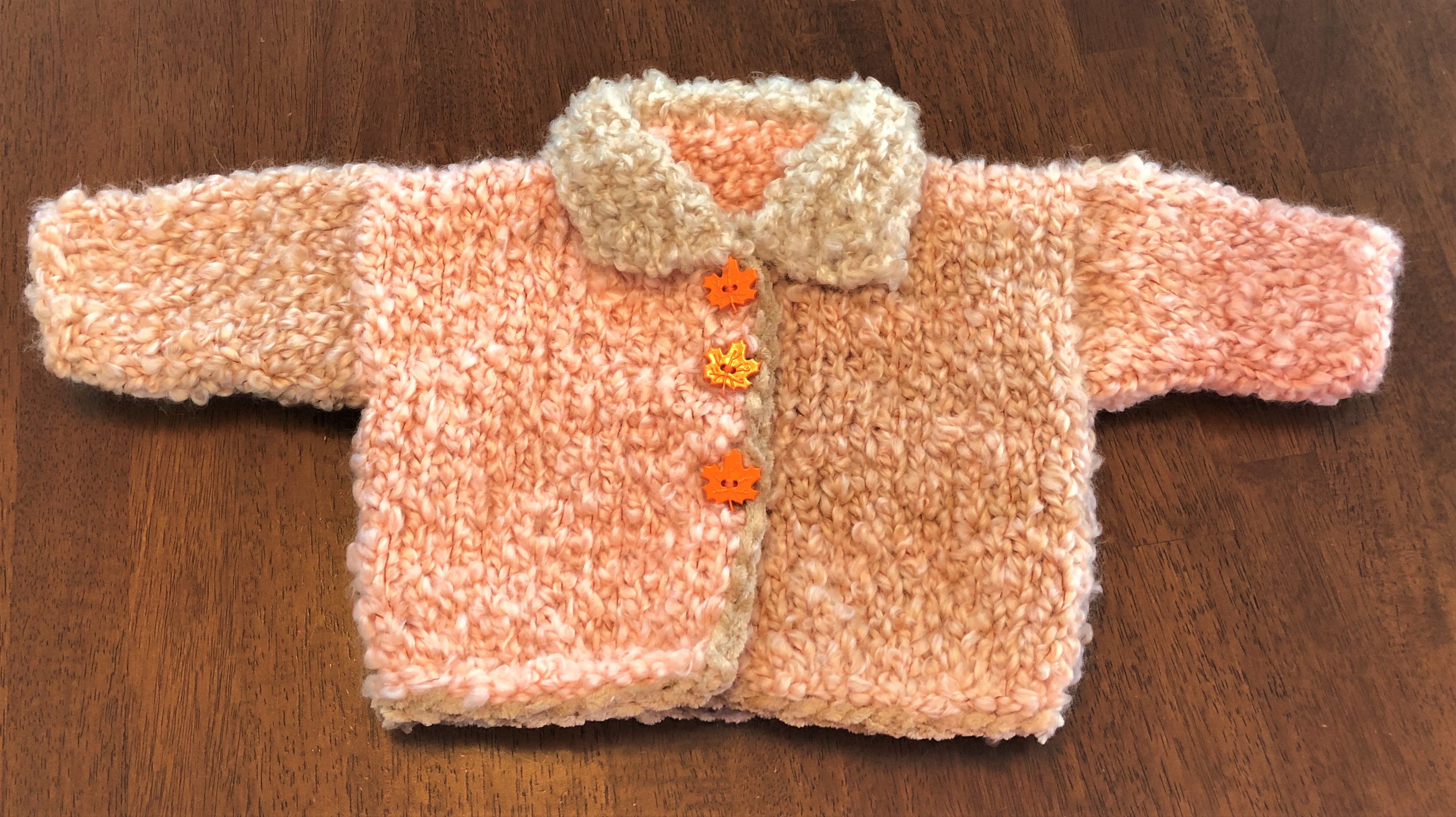
This baby jacket is a match for the previous baby jacket I designed, and posted 😊


Newly designed Jacket with Hat to match.

Materials: 200g of any brand Bulky Yarn (#5 weight) MC & CC; #11 knitting needles – straight; #L crochet hook; 3 medium stich holders; 4 pieces CC scrap yarn, about 3-inches in length; tapestry needle; elastic thread; 3 1” resin buttons

Size: NB to 3 MO

Terms Used:

MC = main color

CC = contrast color

CO = cast on

K = knit

P = purl

st st = stockinette st (knit 1 row – purl 1 row)

sl st = slip stitch (insert crochet hook in back loop and pull thread through, moving onto next st and repeating process)

inc = increase

dec = decrease

x = repeat pattern process

yo = yarn over

tog = together

EO = end off


Jacket Back: With MC, CO 26 st and work in st st fo 9½ -inches. Place 7 sts on a st holder (front)/12 sts (neck back) on a st holder/remaining 7 sts on last st holder (front).

Right Front (Buttonhole side; Girl): Slip sts of this holder onto needle; attach yarn and knit across 7 sts – increasing 2 sts at end of row. P next row. Continue in st st, and inc 2 sts every k row x3 (15 sts on needle). Now P 1 row & K 1 row. Begin to work BUTTONHOLES: K2, yo, k2tog for each buttonhole; make two more buttonholes in same manner, spaced 1½ -inches between.

Work even in st st, until entire piece measures 9½ -inches from shoulder. EO

Back of Neck: Leave sts on holder.

Left Front: K across 7 sts on holder. P next row & inc 2 sts at end of row. Continue in sts st, and inc 2 sts every p row x3 (15 sts on needle).

Work even in st st, until entire piece measures 9½ -inches from shoulder. EO

Sleeves: With scrap yarn bits, mark sleeve settings 4¼ -inches from shoulders (both sides of work). With #L crochet hook, pickup and knit 24 sts between marked area; work in st st on these sts for 4 rows – and dec 1 st of next row. Repeat dec every other row x3 (16 sts on needle). Work eve in st st until sleeve measures 5” from shoulder. EO

Repeat instructions on opposite side for second sleeve.

Remover scrap yarn markers and save for button placements.

Sew side and sleeve seams.

Collar: From front of work, pick up and k 30 sts along front & back necklines. P next row (underside of collar). Work in st st until collar measures 4”. With back of collar facing you, begin at right edge, and trim around collar a with MC sl st crochet edging. EO

Fold buttonhole front over plain front piece, and mark button placements by threading tapestry needle with a piece of scrap yarn and drawing yarn through center st showing through buttonhole hole … this will make an accurate button placement that lines up properly with buttonhole.

Hold jacket with Right Front side facing you, and with CC color, work a sl st edging around entire jacket body for a nice finish 😊 Sew buttons in place.

Finished! Homespun yarn, with Cashmere yarn edging.

Earflap Hat can be found at this link: https://melodys-makings.com/wp-content/uploads/2015/08/I-Cord-Earflap-Hat-Knitting-Pattern.pdf


SAFETY ALERT!! Apple AirTag Tracking Device

Posting from FB Friend: ((((SAFETY ALERT ))))

Yesterday morning when I got into my truck, I received a notification on my phone indicating there was a device that did not belong to me, that could see my location. It turns out someone had planted apple AirTag tracking devices on my truck. This is now how predators are tracking women! If an AirTag is near a phone it is not paired to, it will send the notification after 12hrs. The police department said if the notification pops up DO NOT UNPAIR and contact the police immediately, as if you unpair … it sends a notification to the person who placed it; and they then know they are being sought by police. I want to pass this on to as many females as I can because this is very scary, a terrifying experience that I thought would never happen to me.

The device literally showed my entire route: where I drove, and where I stopped … including my final home destination. Which means that whoever planted the tracking device now knows where I live.

Here are the screenshots of what it looks like:

Notification of being tracked ... and detailed location being transmitted to tracker.

So scary! Please stay safe out here!

WILDFIRE!

I was visiting country friends this morning. The temperature was already 94-degrees, but humidity was around 49%; dressing for the weather is easy-peasy right now, as melting makeup is not a concern in this moment of time 😉

The eyebrow gash is healing nicely.
Beautiful country day; tolerable, and not lung-searing.

One of the gathered friends mentioned the wildfire that was raging along Ocean Beach Highway, in the Flandersville region. When they described the location, all I could think of was that it had to have been sparked sometime before or during the sun slipping over the horizon the preceding evening, because fires do not start by themselves in the cool of early morning hours.

I was also thinking that a natural caused wildfire is actually beneficial to the land, as well as the animals that live in that scorched earth area … the earth can rejuvenate, and the animals can return to the thinned-out region where habitate will offer fresh starts … and abundant food supply as the burned areas begin to freshen up with new growth.

I dount {climate change} has anything at all to do with wildfires. Natural wildfires have been happeing since the dawn of time ... the Earth is designed for cycling natural happanstances.

But I’m not stupid: I know wildfires – natural or not – create a lot of chaos – and pose a very serious risk to the firefighters. I still remember a friend who died fighting a wild fire in 1976. The memory was very poignant this afternoon when I thought of the volunteer firefighters battling those searing flames in today’s hot weather.

The country visit was enjoyable; and though some worried about the {closeness} of the raging fire … it really is no that close to where we were – or even close to where some of them had homes. It seems very close because driving distance is shorter than land travel. But the fire really is in an isolated area.

The raging wildfire is located on a steep hillside, high above the highway – and nowhere near Flandersville homes; it’s not a danger to anything except the forested hillside.

After lunch, we all went our separate ways homeward. I slipped Bob’s testimonial CD in, so I could hear Bob’s voice, and decided to slip over Beaver Creek Road to drive home through smokey Flandersville 😉

I slipped Bob's testimonial CD into the car player ... and set off for home listening to my Gentle Giant's voice.
My husband Bob, and my wolf, Precious; 2012/Nevada Drive.
Ohio Players – ‘Fire’:

I wanted to see what was what, instead of just taking word-of-mouth as truth. The smoke is generated too high on the steep rocky, and heavily timbered hillside, to be camp fire fallout: it’s too isolated.

1-Lane traffic at Little Cape Horn (Flandersville).
Little Cape Horn from Heron Pointe; 17 min., 'as the crow flies' (14.3 mi) via WA-4 W
Wildfire smoke.
Flandersville-WA, seen from Jones Beach-OR, across the mighty Columbia River; today's wildfire is on the timbered hillside, above.
County Firetrucks from Wahkiakum & Cowlitz counties; and Honey Buckets parked in the roadside turnout.

Flandersville is where the mucky-mucks live (Doctor’s families, and such); in the mid-1970’s the Flandersville community divided into twobedroom communities” = city working commutersand changed their community Names to ‘Cape Horn’ (Cathlamet end: richest inhabitants) & ‘Little Cape Horn’ (Longview end, near County Line: inhabitants not so rich … but acting like it).

Flandersville (aka ‘Cape Horn’ & ‘Little Cape Horn’ communities – name changes in mid-1970’s): http://columbiariverimages.com/Regions/Places/flandersville.html

When I got home, I got online to get more info about the fire. What I learned was (1) the fire is still raging; it is fought 100% with manpower, hose lays, (and helicopter water dumps) – but it is not 100% contained (2) it’s burned through 10 acres so far – and will burn through more by this time tomorrow if not brought under control (3) The difficult steep terrain made it necessary to call in 8 crews to work the area: Fire District 1, 2 & 4; Cathlamet Fire Department (100% Volunteer operated); Cowlitz 2 Fire & Rescue; Washington State DNR (Dept. Natural Resources); volunteer Inmate help; and the Wahkiakum PUD (to deal with power lines) were all dispatched to the site (4) Road delays will continue until the area is deemed {safe}: firefighters will deal with the flames, and road crews will deal with loose, and rolling debris (5) cause of fire will be investigated – and fire crews will be working over the area through next week (6) Currently homes are not in any fire danger.

I’ll be going that way again all of this week. So, I’m hoping and praying the fire is contained. Soon 😉